
Desert Online General Trading LLC
Dubai, United Arab Emirates
Desert Online General Trading LLC
Dubai, United Arab Emirates


📍 Map Your Adventure with Precision!
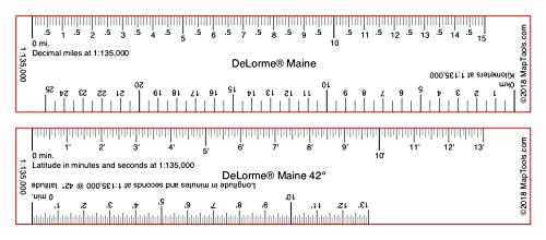
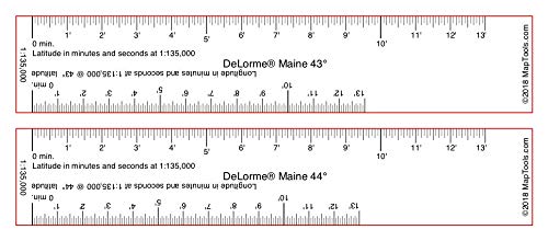
The Ruler Set for DeLorme Atlas & Gazetteers is an essential tool for outdoor enthusiasts and professionals alike, featuring a precise 1:135,000 map scale, dual measurement capabilities for latitude and longitude, and distance rulers for both miles and kilometers, all in a compact and lightweight design tailored for Maine.
| Item Package Dimensions L x W x H | 8.5 x 3 x 0.2 inches |
| Package Weight | 1 Ounces |
| Item Dimensions LxWxH | 8.5 x 3 x 0.2 inches |
| Item Weight | 1 Ounces |
| Brand Name | MapTools |
| Manufacturer | MapTools |
| Part Number | RS-DL-ME |
| Style | Maine |
R**S
Land Nav Must Have for Civilian Delorme Maps
Prior military service, used to old school land nav with military topo maps, protractors, etc. Real world/civilian world, getting those topo maps, etc can be a pain, but I have always had a Delorme Atlas & Gazetteer around for my adventures. I struggled how to accurately plot GPS coordinates, map azimuths and estimate distances properly with the Atlas in the event SHTF and or if I needed to go old school OR was in an area without gps/cell signal, etc. Then I found this product! Match your state/map with the ruler selection, watch the tutorials/read and it will all click. I did get a military protractor to supplement for my azimuth angles etc on the map. The set matches lat/long for your Atlas map and also has a mile/meter ruler in it. I rarely ever write reviews. This product earned my positive review. Prepper, hiker, adv rider, etc must have IMHO. I would solicit knowing your pace count and having some ranger beads in your nav kit along with the other obvious (compass, pen/paper/marker).
J**Y
Must have with Delorme Maps to navigate wilderness
Ease of use
C**C
To scale
Good for estimating distances.
Trustpilot
5 days ago
1 week ago