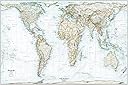
Peters Projection Map | An Accurate World Wall Map | 36x24 Large Detailed Gall-Peters Projection World Map | Laminated
Product ID: 400675627
Details
- BrandAcademia Maps
- ColorBlack and
- Map TypePolitical
- Paper FinishGlossy
- Sheet Size36x24 inches
Gall-Peters Projection or Gall Orthographic - An equal-area map projection that shows countries in the correct sizes relative to each other. It is considered a good alternative to the commonly used Mercator projection which increasingly inflates the sizes of countries the further you move from the equator. This is most noticeably observed with Greenland appearing larger than Africa on a Mercator map despite being 14 times smaller. Highly Detailed - A wide range of cultural and physical features are indicated on the map including: major cities, national capitals, U.S. & Canadian capital cities, rivers, lakes, seas, geologic basins, mountain ranges & peaks, deserts, U.S. state borders and Canadian & Australian provinces as well as latitude/longitude lines. Considerably more detailed than many maps of this size. Each place name label has been positioned meticulously and artistically. Outstanding Shaded Relief - Map's design utilizes the latest 3D rendering techniques for elevation relief to really make terrain look like its rising from the surface of the map. Gorgeous shaded relief detail featured on the map is derived from SRTM (Shuttle Radar Topography Mission) elevation data collected by NASA. Map also features richly textured detail of the ocean floor derived from GEBCO bathymetric data along with labels indicating major ocean floor features. Updated Cartography - The map is up-to-date with all the latest political boundaries and international name changes through 2021, making this among the most up-to-date printed maps available anywhere. Rolled, never folded - Map arrives rolled up, never folded. Ready to hang out of the package! Printed on premium 100 lb. gloss paper. Laminated version is front and back full encapsulation lamination with a dry-erase markable surface. Review: Beautiful! Beautiful! - I purchased this map after long research and canceling other maps after deciding on this one. This is an awesome map. The graphics and quality are outstanding. What I really like is the quality and 100lb paper and lamination quality here provided. These qualities alone give strength and beauty so as to prevent tearing so easy to hang on the wall. If World Maps online creates large United States maps best assured I will purchase one. Beautiful! Thank you. Review: Beautiful Map - It is not easy finding a map to scale, thankfully this one is the best I have owned. This one is great quality, laminated, and lay flat right out of the tube. I like that the colors are subdued so it looks good as a home decoration in addition to still working in the classroom.

| Customer Reviews | 4.5 out of 5 stars 48 Reviews |
M**O
Beautiful! Beautiful!
I purchased this map after long research and canceling other maps after deciding on this one. This is an awesome map. The graphics and quality are outstanding. What I really like is the quality and 100lb paper and lamination quality here provided. These qualities alone give strength and beauty so as to prevent tearing so easy to hang on the wall. If World Maps online creates large United States maps best assured I will purchase one. Beautiful! Thank you.
C**E
Beautiful Map
It is not easy finding a map to scale, thankfully this one is the best I have owned. This one is great quality, laminated, and lay flat right out of the tube. I like that the colors are subdued so it looks good as a home decoration in addition to still working in the classroom.
C**E
It Survived!
The roof went in the Hurricane Ian and THIS SURVIVED!!! It didnt survive "perfectly". Not much else survivied at all...but this sure did! If a review of this Awesome True-To-Continent-Size map surviving a CAT5 Hurricane isn't enough.....well...Lol...😉🥰🥰 We love it it! 😊
L**A
A must for everyone
This world map puts the true perspective of the actual sizes of the counties in relation to each other, we’ve been programmed to think that the countries of the world are a size that they really AREN’T !
O**X
Great product.
Everyone should have a world map at home at this time. Laminating is great because it makes it easier to put it on a wall without having to frame it.
Trustpilot
1 month ago
3 weeks ago